


Webster Twp. Voting District, Rice County, Minnesota
About
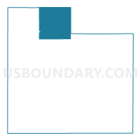
Outline

Summary
| Unique Area Identifier | 604074 |
| Name | Webster Twp. Voting District |
| County | Rice County |
| State | Minnesota |
| Area (square miles) | 35.72 |
| Land Area (square miles) | 35.05 |
| Water Area (square miles) | 0.67 |
| % of Land Area | 98.13 |
| % of Water Area | 1.87 |
| Latitude of the Internal Point | 44.49952960 |
| Longtitude of the Internal Point | -93.34118630 |
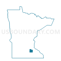
Maps

Graphs
Select a template below for downloading or customizing gragh for Webster Twp. Voting District, Rice County, Minnesota


Neighbors
Neighoring Voting District (by Name) Neighboring Voting District on the Map
- Bridgewater Twp. Voting District, Rice County, MN
- Cedar Lake Twp. Voting District, Scott County, MN
- Erin Twp. Voting District, Rice County, MN
- Forest Twp. Voting District, Rice County, MN
- Greenvale Twp. Voting District, Dakota County, MN
- Lonsdale Voting District, Rice County, MN
- New Market Twp. Voting District, Scott County, MN
- Wheatland Twp. Voting District, Rice County, MN
Top 10 Neighboring County Subdivision (by Population) Neighboring County Subdivision on the Map
- Lonsdale city, Rice County, MN (3,674)
- New Market township, Scott County, MN (3,440)
- Cedar Lake township, Scott County, MN (2,779)
- Bridgewater township, Rice County, MN (1,772)
- Webster township, Rice County, MN (1,768)
- Wheatland township, Rice County, MN (1,237)
- Forest township, Rice County, MN (1,233)
- Erin township, Rice County, MN (859)
- Greenvale township, Dakota County, MN (803)
Top 10 Neighboring Place (by Population) Neighboring Place on the Map
Top 10 Neighboring Unified School District (by Population) Neighboring Unified School District on the Map
- Lakeville Public School District, MN (51,397)
- Northfield Public School District, MN (27,800)
- New Prague Area Schools, MN (18,328)
Top 10 Neighboring State Legislative District Lower Chamber (by Population) Neighboring State Legislative District Lower Chamber on the Map
- State House District 36B, MN (50,199)
- State House District 35B, MN (48,692)
- State House District 25B, MN (45,574)
Top 10 Neighboring State Legislative District Upper Chamber (by Population) Neighboring State Legislative District Upper Chamber on the Map
- State Senate District 35, MN (108,564)
- State Senate District 36, MN (96,657)
- State Senate District 25, MN (85,965)
Top 10 Neighboring 111th Congressional District (by Population) Neighboring 111th Congressional District on the Map
Top 10 Neighboring Census Tract (by Population) Neighboring Census Tract on the Map
- Census Tract 811, Scott County, MN (10,329)
- Census Tract 701, Rice County, MN (6,614)
- Census Tract 702, Rice County, MN (5,314)
- Census Tract 615.02, Dakota County, MN (2,861)
Top 10 Neighboring 5-Digit ZIP Code Tabulation Area (by Population) Neighboring 5-Digit ZIP Code Tabulation Area on the Map
- 55044, MN (47,218)
- 55021, MN (29,732)
- 55057, MN (24,602)
- 55046, MN (5,211)
- 55020, MN (3,717)
- 55019, MN (1,817)
- 55088, MN (1,704)